AIS has evolved into an important safety aid for situational awareness and even collision avoidance. However, this evolution also brings new risks, and over-reliance on AIS may, in some cases, contribute to incidents rather than prevent them.
Written by

Published 14 July 2026
It has been nearly 25 years since the tragic event of 9/11 – a turning point that underscored the vulnerability of ships and other maritime infrastructure to potential misuse. In its aftermath, the ISPS Code was introduced to strengthen maritime security, and the Automatic Identification System (AIS) emerged as an essential tool for vessel tracking and identification.
AIS has since become an indispensable aid to maritime security and navigational safety. However, its widespread adoption – both on ships and in broader maritime applications such as aids to navigation (AtoN) and the marking of fishing gear and aquaculture areas – has increasingly shaped bridge watchkeeping practices and collision-avoidance behaviour. For bridge teams, pilots, and VTS operators, where navigational safety is critical, the integration and display of AIS information on navigational displays, particularly radar, have made traffic information more readily accessible – supported by requirements such as MSC.192(79) and MSC.191(79).
While these developments have delivered significant safety benefits, they have also increased the potential for over-reliance on AIS-derived information. In some cases, such over-reliance may contribute to incidents, particularly when it influences the assessment of navigational risks or the decisions taken on the bridge or in VTS services.
When AIS becomes too trusted
Reflecting on my own seafaring career, I recall when AIS was a novelty. It greatly simplified the identification of nearby vessels and enabled more direct communication. AIS also compensated for radar limitations in adverse weather or in waterways with bends, or other intermediate obstructions. Later, in my roles as a VTS supervisor and casualty investigator, AIS proved invaluable for streamlining ship reporting and reconstructing incidents.
However, I also observed that many accidents occurred when bridge teams relied primarily on AIS for collision avoidance, neglecting systematic visual and/or radar observations. This is concerning because, as outlined in the IMO Resolution A.1106(29), AIS calculate collision risk using dynamic data from both own vessel and AIS target. Radar plotting, by contrast, evaluates how a target moves relative to own ship.
In my current role as a Loss Prevention Executive, I continue to see incidents related to the improper use of AIS. Over-reliance on AIS – what I refer to as AIS-assisted collisions – remains a recurring factor in marine casualties. It is crucial for mariners to recognize the limitations of AIS and to use it as a supplement, not a substitute, for fundamental navigational practices such as visual lookout and systematic radar observation or radar plotting.
Case studies: Common patterns in AIS-related collisions
Case 1: Collision between tanker S and bulker C
At 1950LT on 6 January 2018, the laden Suezmax tanker S collided with the laden Panamax bulk carrier C at the East China Sea, resulting in the loss of life for 32 persons on the tanker and significant pollution.
The investigation revealed:
There were significant discrepancies between the tanker’s AIS data and its actual navigation, with course over ground (COG) differing by 20 to 25 degrees and speed over ground (SOG) by 2 to 3 knots.
The tanker’s bridge team failed to acquire the bulker on her X-band radar and did not activate the AIS target for the opposing vessel. The bulker’s bridge team did not perform radar plotting for the tanker relied solely on the tanker’s AIS displayed on the radar to check CPA.
According to the investigation, the COG and SOG transmitted by the tanker’s AIS were derived from her speed log, which did not conform to the data from her GPS.
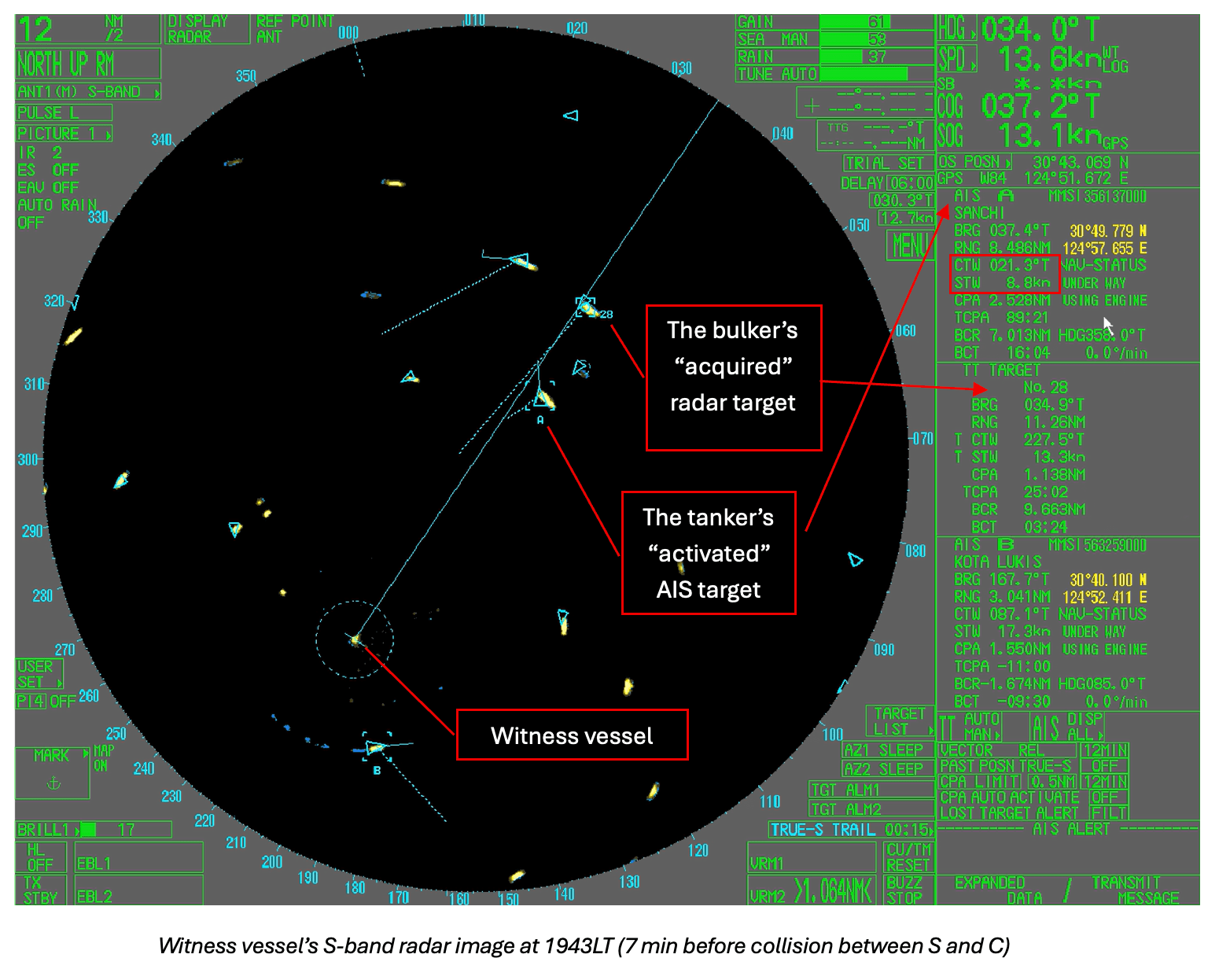
The radar image from a witness vessel showed both tanker S’s “activated” AIS target and the bulker’s “acquired” radar target clearly. At this specific time, tanker S’s AIS transmitted course was 021 degrees and speed 8.8 kn. Such dynamic AIS information would be used for the calculation of CPA and TCPA with tanker S for other vessels in the vicinity including bulker C. However, tanker S’s actual course was about 358 degrees and speed 10.5 kn.
Lessons learned: AIS data reliability depends on the accuracy of its connected sensors. If AIS is transmitting inaccurate information, it can create situational confusion rather than improve awareness.
Case 2: Collision between bulk carrier V and fishing vessel L
At 0419 on 18 September 2020, bulk carrier V collided with fishing vessel L in the Laotieshan TSS, resulting in the loss of life for all 10 crew members onboard the fishing vessel.
The investigation revealed:
The bridge team on vessel V primarily relied on AIS and ECDIS for lookout, while neglecting fundamental methods such as visual lookout and radar plotting. No radar plotting was conducted for the fishing vessel involved in the collision, nor for its accompanying fishing vessels prior to the incident.
The fishing vessel L failed to maintain effective operation of its AIS equipment. Its AIS signal was detected right before the collision, making early detection and tracking via the AIS system by other vessels and the VTS center impossible.
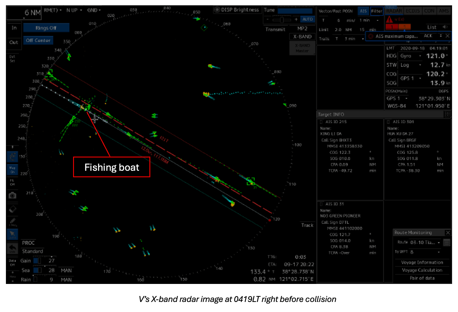
Lesson Learned: Not every vessel has a working AIS, so it is important not to rely only on AIS for lookout. Always use visual lookout and systematic radar observation in addition to AIS to ensure safe navigation.
Case 3: Collision between bulk carrier J and fishing vessel L
At about 0150LT on 22 December 2022, bulk carrier J collided with fishing vessel L in the Yellow Sea, causing the loss of 11 crew members onboard the fishing vessel.
According to the investigation, the bridge team on the bulk carrier did not plot the target of fishing vessel L, nor did they activate her AIS target on the radar even at 0143LT when it became a Dangerous AIS target (in this case, an AIS target (activated or not) calculated to pass preset CPA of 0.3 nm and TCPA of 12 min limits). Until 0146LT, the AIS target of L was activated on the X-band radar, and the AIS information was used for collision avoidance.
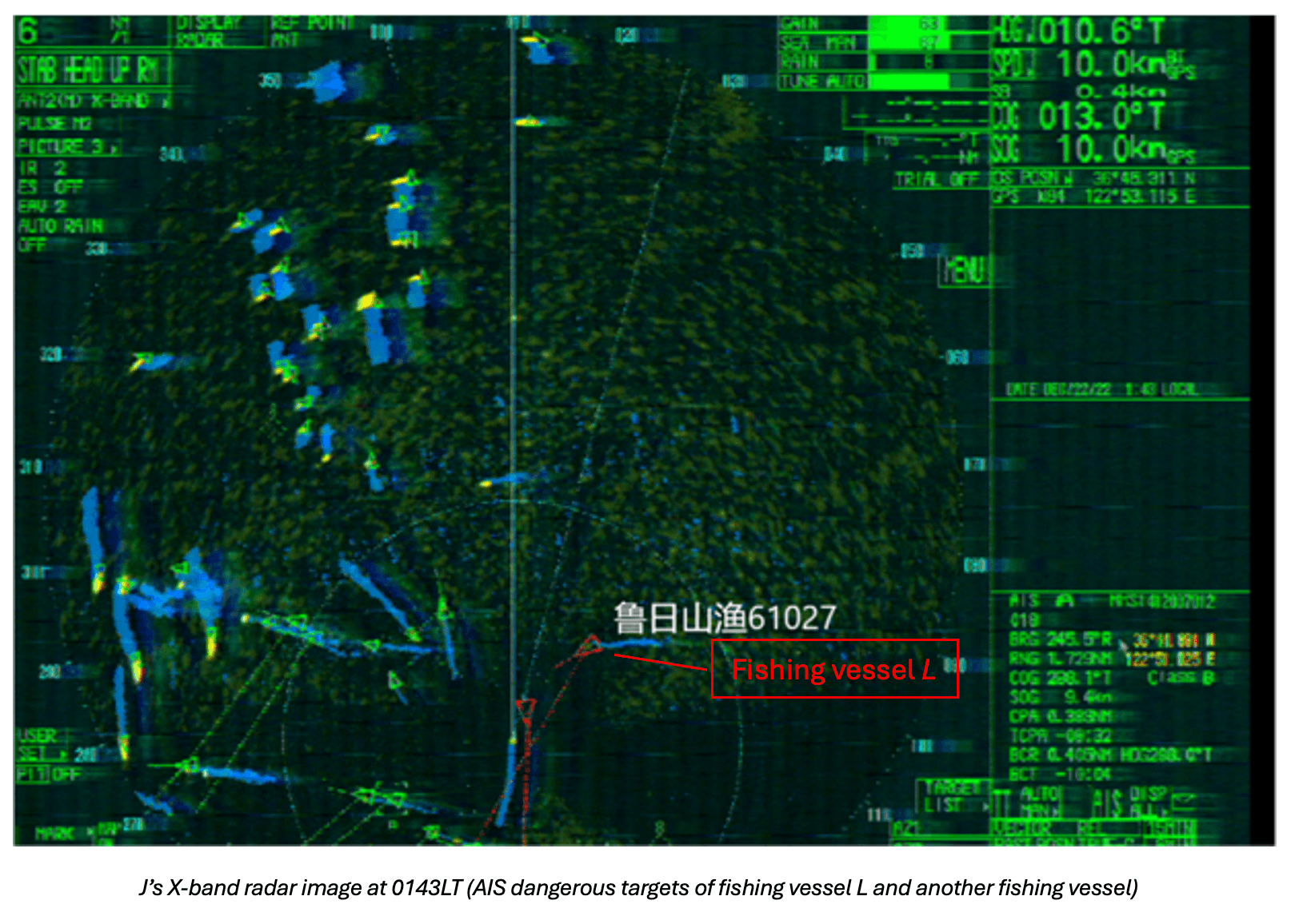
Lesson Learned: Don’t wait until the last minute to assess the risk of collision. Always monitor and evaluate approaching vessels early, using all available means, so you have enough time to take action and avoid collision.
Case 4: Collision between bulk carrier T and STS tanker S1 and S2
At 2330LT in July 2024, bulk carrier T, while enroute to Subic Bay, Philippines, came in collision with tanker S1 at anchor carrying out STS operations with another tanker S2. Damage was sustained by all three vessels.
It was found that:
No AIS feed was available from both tankers until about 1 min before the incident when S2’s AIS signal first appeared on T’s radar and ECDIS displays.
The radar echoes of both tankers had been visible on T’s radar since 2250 LT. But the OOW did not plot the targets on the radar and was primarily using the AIS data reflected on the ECDIS for determining risk of collision.
The ECDIS had a Radar Image Overlay (RIO) feature, but this was not used before the incident.
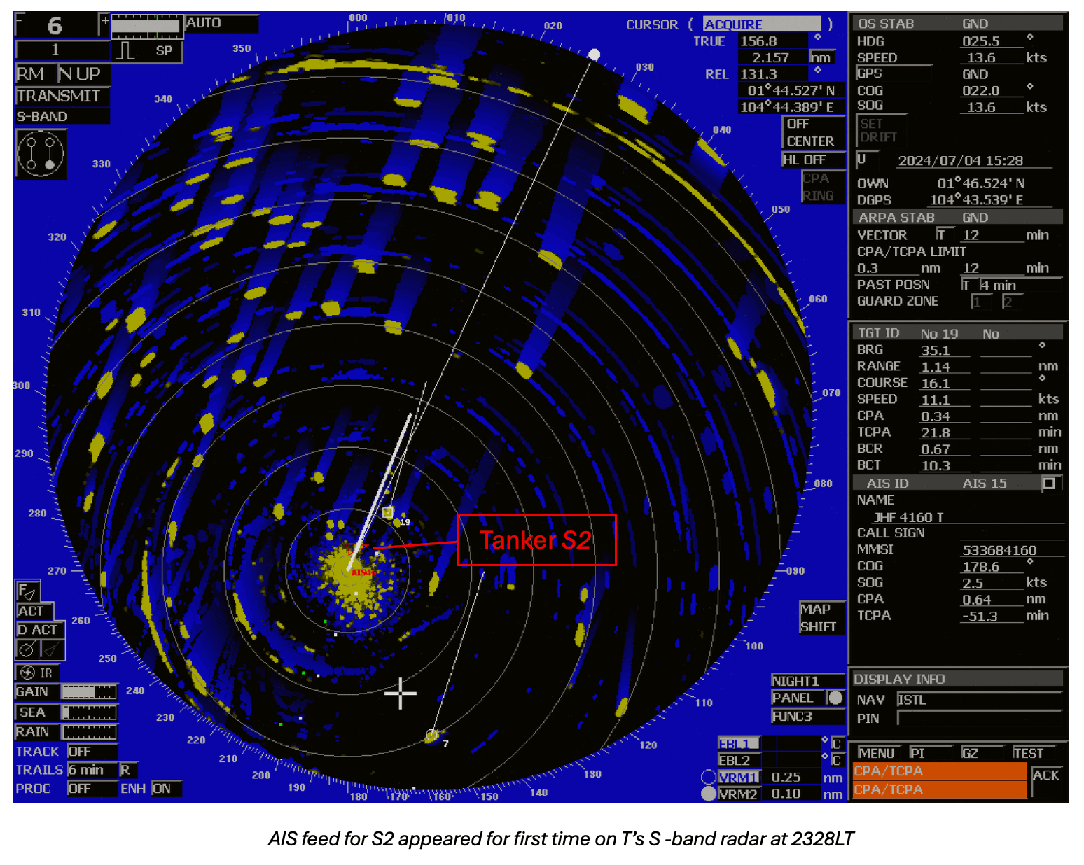
Lesson Learned: Don’t rely only on AIS data displayed on the ECDIS to determine the risk of collision. Always use radar and other available aids to get a complete picture to make safer decisions.
Why mariners over-rely on AIS
One contributing factor may be the way trust gradually shifts toward tools that provide fast, clear, and seemingly authoritative information. AIS offers immediate identification and CPA/TCPA outputs, which can create a perception of reduced risk and reliability, particularly in busy or restricted waters. Over time, this may unintentionally lead to a reduced emphasis on traditional cross‑checks, such as visual lookout and systematic radar observation.
A lack of cross‑verification is often associated with well‑recognised human‑factor mechanisms, where information from a single, convenient source is accepted without adequate validation against alternative inputs. In such situations, inaccuracies or interruptions in AIS data may go unnoticed, not because operators are unaware of AIS limitations, but because confidence in the system has gradually displaced routine redundancy checks – both on the bridge and, in some cases, ashore. This is illustrated by the Turkish Marine Safety Investigation Board’s investigation into a collision in a VTS area where reliance on AIS affected situational awareness.
Recommendations
Mariners should be aware of the limitations of AIS, which include refresh delays in data transmission, dependence on properly functioning sensors, and incomplete traffic coverage – not all vessels carry AIS, sensors may malfunction, and some vessels such as navy ships (as highlighted in this investigation) may operate in passive mode. Over-reliance on AIS without accounting for these limitations has been a recurring factor in the incidents described above.
Safety Management Systems (SMS), masters’ standing orders, and night orders should reinforce the importance of maintaining a proper lookout using all available means.
The increasing risk of GPS interference and disruption in geopolitical conflict zones is also impacting the reliability of AIS data. Mariners are encouraged to use terrestrial navigation skills such as manual fixes and radar overlay on ECDIS to cross-check vessel’s position and to validate surrounding traffic information. Safe navigation requires the integration of multiple sources, not reliance on any single system.
Finally, pilots often connect their portable pilot units (PPUs) to the vessel’s AIS, which may be subject to GPS “smoothing”, leading to incidents such as the reported allision with berth when the predicted vessel positions displayed on the PPU do not accurately represent the vessel’s future track.
Relevant links:
USCG: Automatic Identification System (AIS) – Accurate Broadcasts Don’t Happen Automatically
Maritime & Coastguard Agency: MGN 324 (M+F) Amendment 2 - Use of Automatic Identification System (AIS)
INTERTANKO: Jamming and Spoofing of Global Navigation Satellite Systems (GNSS)
Nautical Institute: All about AIS
Gard article: GPS interference in geopolitical conflict zones
Related Articles


Gard is a member of