Every year on World Whale Day, we are reminded that whales are more than ocean icons. They are key indicators of the health of the seas on which our industry depends. As global vessel traffic rises and shipping lanes increasingly overlap whale migration routes, the risk of collisions and disturbance grows.

Published 13 February 2026
World Whale Day takes place on the third Sunday in February, which this year falls on 15 February. It was first established in Hawaii to celebrate native humpback whales and has since grown into an international day celebrating all whales and raising awareness of the risks they face. It is also a good opportunity to reflect on what the shipping community can do to help.
Awareness of whale areas and careful voyage planning are essential to protect these animals and maintain safer operations at sea. This responsibility does not apply only on World Whale Day, but every day of the year.
Every knot counts
Vessel strikes are one of the most direct threats to whales and, along with entanglement in fishing gear, they are a leading cause of death and injury to whales. Many whale species live and migrate near major ports, often overlapping with busy shipping lanes. Despite their often large size, they are not always easily visible at the sea surface, making them difficult for crews to spot. Even when crews do spot a whale, high vessel speeds may leave too little time to avoid a collision.
Research shows that higher vessel speeds increase both the likelihood and severity of a collision. A modelling study on North Atlantic right whales found that more than half of the whales located in or swimming into the path of an oncoming vessel traveling at 15 knots or more are likely to be struck, even when attempting evasive action. The study also indicates that reducing a conventional vessel’s speed from 20–25 knots to 12–13 knots can lower the risk by about 30 per cent, while slowing further to 10 knots can reduce it by roughly 40 per cent. Slower speeds give vessel crews more time to take evasive action and may also improve whales’ ability to avoid collisions.
According to the International Whaling Commission (IWC), there is no universal solution to the problem of vessel strikes. However, it is generally agreed that the safest approach is to keep whales and vessels apart. Where this is not possible, vessels should reduce speed and maintain a dedicated lookout. The IMO issued a guidance document for minimizing the risk of ship strikes with cetaceans in 2009 (MEPC.1/Circ.674), encouraging Member States to identify species of concern, assess their interaction with vessel traffic, and consider measures to reduce the strike risk. Since then, many coastal states have launched initiatives to support this, including traffic separation schemes and routing measures, areas to be avoided, and speed restriction zones. Some of these measures are mandatory and legally enforceable, while others are just voluntary.
Underwater noise
In addition to the risk strikes, whales face another serious threat from shipping: underwater radiated noise (URN). Marine mammals rely on sound as their primary means of communication and to navigate and assess their environment. Commercial shipping is a major source of URN, produced primarily by propeller cavitation and onboard machinery. Low-frequency sounds from large vessels travel efficiently over long distances in deep-water environments and can potentially disorient whales, disrupt their social interactions, interfere with feeding, and in some cases, cause temporary or permanent hearing damage.
The IMO has recognised the impact of vessel noise on marine life and issued a set of guidelines on the reduction of URN from commercial shipping (MEPC.1/Circ.906/Rev.1). Last updated in November 2024, these guidelines are designed to help shipowners, designers, and operators identify ways to minimise URN at its source.
While the greatest opportunities to reduce URN occur during a vessel’s design, operators and crews can also make a difference. Keeping propeller surfaces smooth, minimising hull roughness, and maintaining machinery to limit vibrations all help reduce noise levels. Adjusting routing, speed, and operational profiles, as well as reducing time at anchor, can further limit URN in ports and other sensitive coastal areas. Many of these measures also align with energy-efficiency practices, offering co-benefits such as improved whale protection, reduced fuel consumption, and lower overall operational costs.
Plan your voyages
Incident reporting and awareness of how vessels can affect whales are increasing, but as the number and size of vessels grow, so do the risks. Many seafarers may also still be unaware of these threats, making it essential to identify areas with large whale populations and migration routes during voyage planning. The first challenge, however, is simply knowing where the whales are likely to be.
To support this, the WWF and research partners have launched an interactive map of global whale migration routes, known as Blue Corridors. The map illustrates how whales travel between feeding, breeding, and social areas, and how growing threats, such as vessel strikes, entanglement in fishing gear, underwater noise, plastic pollution, and climate change, intersect with their migration routes.
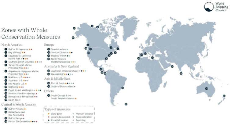
Another useful resource is the World Shipping Council’s (WSC) WSC Whale Chart, a global a global voyage planning aid designed to help protect whales. The chart provides detailed information on existing whale conservation measures worldwide, including mandatory and voluntary speed restrictions, areas to avoid, and routing measures. The chart also links to sources that track temporary measures, which may change frequently based on whale presence. Measures are organized geographically and updated regularly.
To improve accessibility, the California Marine Sanctuary Foundation (CMSF) has digitized the WSC Whale Chart and developed the Whale Atlas, a mariners guide to whale-safer shipping. The regions to be aware of as of November 2025 are shown in the map below.
Recommendations
We strongly recommend that resources and tools, such as those mentioned above, be available onboard at all times. In addition, collect whale sighting information from all available sources to support prudent voyage planning to and from ports in areas where whales may be present. Coastal states’ notices to mariners and various whale alert apps and online maps can assist this process.
Vessel operators should also:
Ensure crews receive basic training on precautionary measures when operating in areas where whales are known to be present, including whale identification and reporting. Learn more about the appearance and behaviour of whales from the US National Oceanic and Atmospheric Administration’s (NOAA) species directory.
Verify active speed restriction zones before and during voyage. Some authorities may activate temporary speed restriction zones at short notice if whales are confirmed in certain locations.
Encourage masters to reduce vessel speed in areas with voluntary speed restrictions and to avoid regions with reported whale concentrations. Emphasise the importance of cautious navigation and posting lookouts experienced in spotting whales. Optimal routing and lower speeds will also reduce noise levels.
Instruct crews not to intentionally approach whales, as this may violate local laws. Alert other vessels in the area when a whale is sighted.
Provide a written report to the company and, where applicable, to local authorities as soon as possible following a whale strike.
For vessels trading to the US, review and update procedures for pre-arrival reporting to ensure compliance with its Mandatory Ship Reporting System.
Useful sources
International Whaling Commission: Collisions between whales and vessels
The OCEAN Project: Best practices to avoid ship whale strikes (video)
US NOAA: Vessel strikes information page. An interactive speed zone dashboard shows compliance with the mandatory North Atlantic right whale vessel speed regulations.
Transport Canada: Protecting whales
GloNoise Partnership: A UN-supported initiative whose ultimate goal is to reduce underwater noise from shipping and mitigate its negative effects on marine ecosystems and living resources.
Related Articles


Gard is a member of