So far this year, the number of weather-related incidents off the coast of South Africa has reached the same level as the combined total for the last three years. In this article, we highlight the key weather-related and navigational risks associated with rerouting off the Cape of Good Hope, the high-risk areas to be aware of, and which vessel types are most at risk for severe accidents and claims.
Written by
Published 23 October 2024
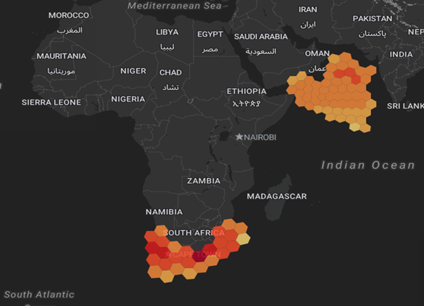
Over the past few years, Gard has seen a significant number of heavy weather-related incidents off the South African coast, as visualized in the heatmap above. However, just in the course of the first nine months this year, the number of incidents recorded in the region has reached the same level as the combined total for the three-year period from 2021 to 2023.
This of course reflects that the traffic outside the Cape of Good Hope has increased substantially since the start of the Houthi attacks in the Red Sea. The rerouting of ships not only adds 10-14 days of transit time – it also exposes the vessels to harsher weather and increased risk of damage and claims, as highlighted in our recent Gard article.
This article dives deeper into the weather-related and navigational risks associated with diverting off South Africa. We highlight the areas where we see most accidents, which types of vessels are most exposed, and the precautions shipowners and mariners should be taking when rerouting to this area.
Massive shift in traffic
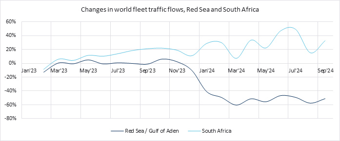
Some of the diversion away from the Red Sea started already shortly after the Hamas attack in Israel in October 2023, but most of the change in traffic flow happened after the Houthi’s seizure of the cargo ship Galaxy Leader on 19 November 2023, as shown in the graph below. The Galaxy Leader was the first vessel that was directly impacted by the Houthi attacks.

This graph shows the percentage change in traffic flow in the Red Sea and outside South Africa, using January 2023 as baseline. Vessels transiting through the Gulf of Aden with their AIS turned off have not been included. Source: Gard, Windward.
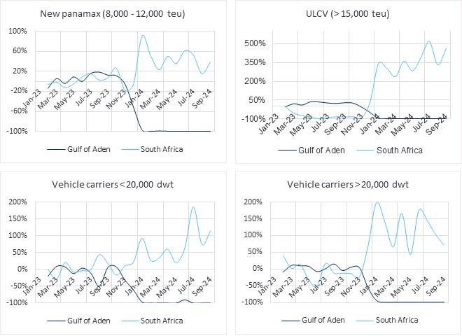
Which vessels in particular have chosen to divert and take the longer route around the Cape? In relative terms, the greatest increase in the traffic has come from larger vehicle carriers and container vessels, as show in the graphs below. Prior to the geopolitical tensions in the Red Sea and the Gulf of Aden, hardly any vessels of this size took the route around the Cape.
Changes in traffic flows for container vessels and vehicle carriers

The graphs above show percentage change in traffic flow in the Red Sea and off South Africa for vessels insured by Gard for P&I and/or H&M, using January 2023 as baseline. A traffic reduction of 100% signifies that no vessels were transiting through the Gulf of Aden during that period. Source: Gard and Windward.
Hot spots for high waves
In general, the weather conditions outside South Africa are much more challenging than in the Arabian Sea. In fact, for each month from January 2023 till September 2024, both the total swell height and maximum wave height were higher off South Africa than in the Arabian Sea, according to data from Gard and Windward. For further details, see this Gard analysis. Admiralty Sailing Directions for this area also confirm the same, stating that abnormal waves may be experienced at any time of the year.
The below map shows the max wave height observed for different areas outside South Africa and in the Arabian Sea. The maximum wave height is highest outside Port Elizabeth followed by the waters off Cape Town and Saldanha. The area outside Port Elizabeth is also where we have seen most of the weather-related claims, as shown in our heat map further up.

Max wave heights observed outside South Africa and in the Arabian from January 2023 to September 2024. Source: Gard, Windward
Navigational challenges
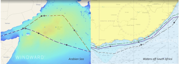
Whilst the principles of avoiding a storm or region of heavy weather are not region dependent, there are a few differences in terms of execution and the options available in the Arabian Sea and the waters off South Africa. In the Arabian Sea, vessels have adequate sea room to alter course and avoid the worst weather whilst also maintaining safe distance from shore. Vessels transiting off South Africa, however, have fewer routing options, as shown in the screenshots below.

The screenshot to the left shows the routes taken by two vessels to avoid an area of heavy weather in the Arabian Sea. The screenshot on the right shows three vessels taking different routes outside South Africa at a time when strong winds and high waves disrupted shipping in the region. The navigational options here are fewer. Source: Gard (via the Windward Maritime AI™Platform)
In other words, mariners face a dilemma when sailing outside the Cape in stormy weather: should they stay near the coast to find calmer waters as recommended in the Sailing Directions, or should they sail in deeper waters, seaward of the continental shelf? Staying close to shore can limit reaction time and options available in emergencies, while deeper waters may expose vessels to harsher weather. The increase of traffic in the region of course further complicates the situation.
Key risks and recommendations
Vehicle carriers and container vessels – the vessel types that in relative terms have constituted the biggest increase in traffic outside the Cape – have the highest frequency of weather-related claims, according to Gard’s H&M claims data for the period 2015-2023. This is partly due to the sheer number of cargo units these vessels carry, making them more susceptible to damage from lashing or stowage failures, and any failure in lashing or stowage on one unit can trigger a domino effect. Whether it is a container vessel, vehicle carrier, general cargo vessel carrying breakbulk cargo or any other type of vessel, cargo lashings should be able to withstand the anticipated weather and vessel motions, and the crew should have evidence to support this. Please refer to this guidance prepared by Minton, Treharne and Davies Limited on lashing and securing arrangements.
There are also other risks shipowners and mariners should bear in mind. Severe weather can cause vessels to lose propulsion, making them susceptible to the elements and potential hazards like collisions or groundings. In many heavy weather-related claims handled by Gard worldwide, there have been instances of either temporary or prolonged loss of propulsion. Such incidents often lead to the vessel being broadside to the waves, resulting in heavy rolling. If this occurs in a busy waterway, it poses a navigational risk to other vessels. In a few cases, vessels were not able to regain propulsion, and salvage/towage had to be arranged. For further details on the technical reasons for loss of propulsion, please refer this ABL guidance.
Lastly, we would like to emphasize the crucial role of proper weather routeing. Analyzing the wave height data for vessels that have had a heavy weather-related claim off South Africa, it seems that they were unable to avoid high waves despite the availability of advanced weather routeing tools and services. It is worth noting that we have observed that weather routeing advice to a vessel can vary depending on whether the principal is a charterer or an owner, which ideally should not be the case. Our recommendation therefore is that clarity and a common understanding among all stakeholders (owners, managers, charterers, routing service providers, and crew) regarding the weather thresholds for every voyage.
We would like to thank ABL and Minton, Treharne and Davies Limited for their help in preparing this insight.
Related reading


