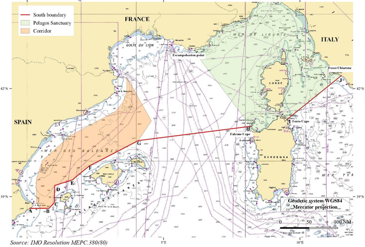
The IMO has adopted a new voluntary speed restriction scheme in the North-West Mediterranean Sea to protect local whale populations. This area is also marked on the newly released global whale chart aimed at helping seafarers in planning their voyages to reduce the risk of vessel-whale collisions.

Protecting whales – in the Mediterranean and everywhere else
Published 28 November 2023
Collisions between vessels and whales, vessel strikes, are a global concern and can occur wherever there is an overlap between whale activity and vessel traffic. Although separation of shipping lanes from whale habitats is the most effective way to prevent vessel strikes, experience has shown that speed reductions reduce the risk substantially when implemented in locations where re-routing of vessels is not possible. Not only is the impact of the collision less harmful with reduced speed, but both parties have more time to avoid each other and prevent a collision in the first place.
New voluntary speed restrictions in the Mediterranean Sea
The IMO’s recent designation of the North-Western Mediterranean Sea as a particularly sensitive sea area (PSSA) is the latest addition to the list of government initiatives to protect whales from international shipping. This designation includes recommended protective measures intended for commercial ships and pleasure yachts of 300GT and above. Such vessels are, among other things, asked to navigate with particular caution in areas where whales have been detected and reported, and to reduce their speed to between 10 and 13 knots.
The North-Western Mediterranean Sea PSSA is located between the coastlines of France, Italy, Monaco and Spain and its precise description and location, including navigational coordinates, originated in IMO Resolution MEPC.380(80).

Introducing the WSC Whale Chart
Although minimizing the risk of collisions with whales should be a routine element of vessels’ passage planning, it can be difficult for seafarers to keep track of all the mandatory and voluntary governmental initiatives globally aimed at saving whales. As a result, the World Shipping Council (WSC) has created the first-ever worldwide mapping of all mandatory and voluntary governmental initiatives to reduce harm to whales from vessels. The new WSC Whale Chart outlines critical navigational coordinates and concise graphics that will assist seafarers in identifying routing measures and areas subject to static speed restrictions.
“We hope that by compiling this unique navigational aid, keeping it updated and making it available for free to all navigators, we can help reduce ship strikes and safeguard endangered whale populations across the globe” says the WSC.
The WSC Whale Chart can be downloaded here: https://www.worldshipping.org/whales
Preparations and awareness are key
Collisions with whales can occur in the open ocean, in high-traffic areas such as shipping lanes, and inshore areas including ports. Virtually any type of vessel can be involved, from large cargo vessels and cruise ships to small outboard recreational crafts, as could any species of whale or cetacean. However, while large passing ships are unlikely to see a whale and may even be unaware that a collision has taken place, smaller vessels involved in vessel-whale collisions can suffer substantial damage and personnel injuries. Therefore, this is a concern for both animal welfare and marine safety.
It is a vessel operator’s responsibility to ensure that its crews are aware of the potential for vessel collisions with whales and we recommend to:
Make active use of the most recent version of the WSC Whale Chart in your passage planning.
Collect information about whale sightings prior to entering areas known to be home to whale populations.
Encourage masters to reduce the vessel’s speed while transiting areas with voluntary speed restrictions, or alternatively route around the area, and post lookouts who are familiar with spotting whales.
Ensure crews keep an adequate safety distance from any whales observed or detected in close quarter situations, as well as report any sightings.
Note also that violations of any mandatory speed restrictions can lead to civil administrative penalties being issued against the vessel.


