Newly opened Parana River channel has seen a spate of groundings since its opening in April 2025.
Published 18 June 2025
According to our local correspondent in Argentina, Sigvart G.J. Simonsen & Cia. S.R.L., a new channel, the Principal Channel opened along Paso Fighiera in the Parana River. in April 2025. The new channel and its accompanying routing changes are just south of the regularly used 'main channel,' between markers KM 391.7 and KM 380. These changes are illustrated below.
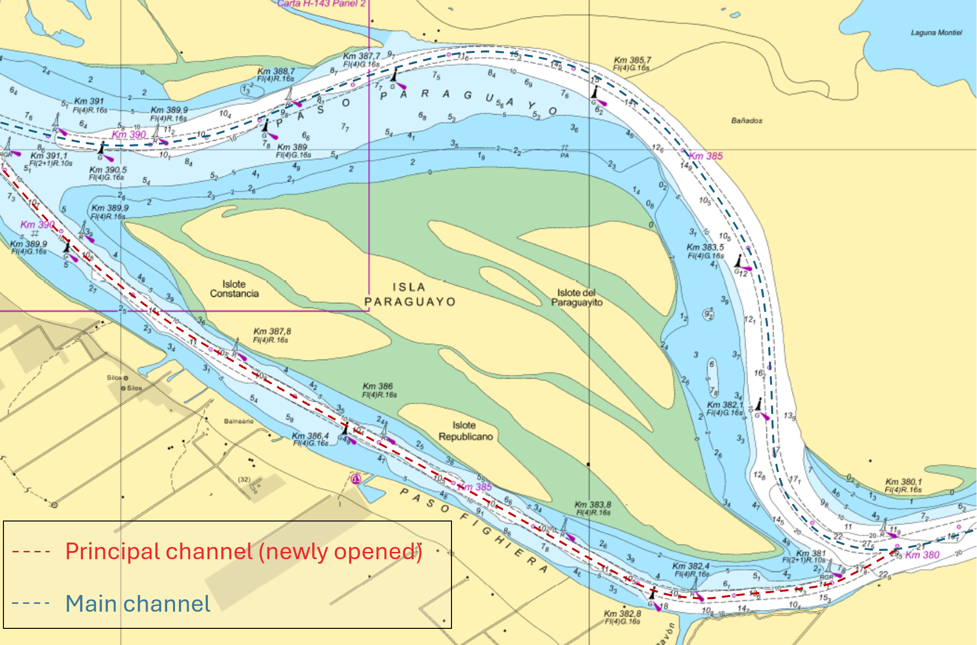
The regularly used ‘Main Channel’ and the newly opened ‘Principal Channel’ along Paso Fighiera.
Gard is aware of at least three grounding incidents having occurred within this newly opened Principal Channel since April. Two of these are briefly outlined below.
Case studies
Case study 1
With a draft of 10.2 meters, the vessel began its journey downriver. Upon reaching marker 391.7, the river pilot adjusted the course to 130 degrees, intending to guide the vessel through the Principal Channel. However, just minutes later, while operating outside the designated main channel, the vessel ran aground just west of marker 389.9. Refloating efforts took two days. After the incident, the pilot commented that the channel lacked sufficient navigational markers, according to the bridge team.
Case study 2
The laden vessel departed downriver with a draft of 9.9 meters. Approaching the 391.7 marker, the Pilot informed the Master of a change of plans: they would proceed via the newly opened Principal Channel instead of the usual Main Channel. The vessel's electronic charts lacked depth data for the new channel, but the Pilot assured the Master it was suitable for their draft and recommended by the Coast Guard. Despite receiving these assurances, the vessel ran aground in the middle of the Principal Channel and took nearly five days to refloat.
The investigation into these incidents highlighted the following key points:
The passage plan was based on using the main channel as the Pilots did not inform the Master of their intent to use the Principal Channel during the routine Master-Pilot exchange (MPX) before departure.
The presence of strong currents was not discussed during the MPX. The river in this area presents significant navigational challenges due to unpredictable and strong cross currents that occur as it splits around islands.
Despite having tablets with charts, pilots were not consistently using them for navigation. While not relevant to these case studies, the vessel managers noted that some pilots prefer using their phones to access the charts.
The latest ENC corrections for the electronic charts did not reflect the channel depths, limits or buoy markings. One of the electronic chart providers that we contacted at the time of preparing this alert, has confirmed that the most recent correction lacks bathymetry information and details on fairway limits for the Principal Channel (ENC cell no. AR401430). They also noted that, while some buoys are marked, there is insufficient information to meet its declared CATZOC B category.
Traffic movement
Analysis of AIS data reveals that merchant vessels with a deadweight exceeding 5,000 tonnes commenced transit through the Principal Channel in Week 13 in March 2025. Over subsequent weeks, there was a consistent increase in the number of vessels using the Principal Channel. This period (Week 13 to Week 24) also coincided with a steady decrease in traffic through the Main Channe, as indicated in the below graph.
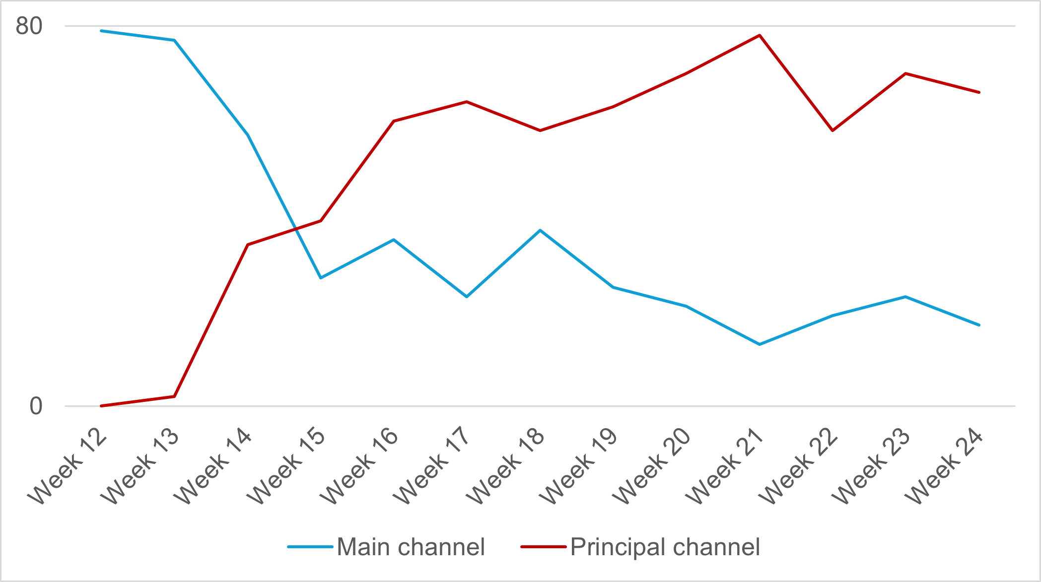
Number of vessels transiting the two channels. Includes all merchant vessels > 5,000t dwt (Source: Windward Maritime AITM)
When looking at vessel types using the Principal Channel, bulk carriers - primarily Handysize and Panamax - are the most common, with chemical/oil tankers coming in second, as the detailed chart below illustrates.
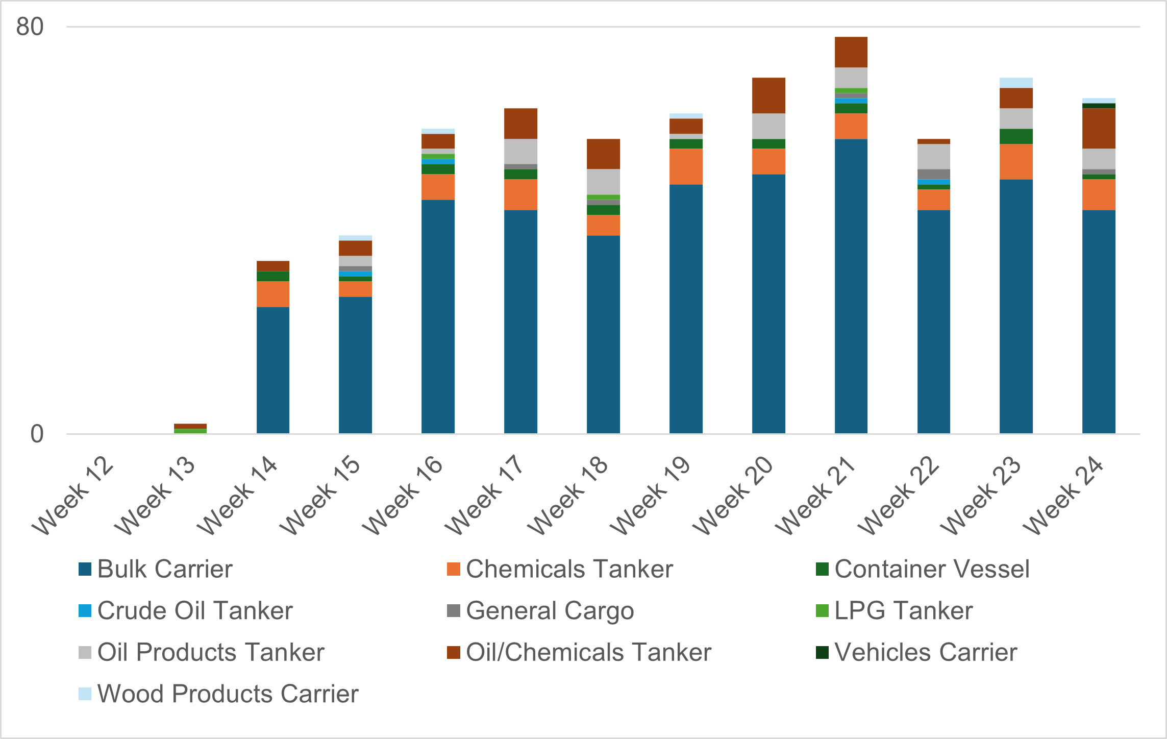
Type of vessels transiting the newly opened Principal Channel (Source: Windward Maritime AITM)
Further information
Our local correspondent advises that mariners can refer to the following sources for updated information:
‘Boletin Fluvial’ (River Bulletin,). For changes in buoyage, go to ‘Section 4, Cambios En El Balizamiento’ (Changes in Buoyage).
‘Radioavisos Nauticos’ (Nautical Radio Warnings). Go to ‘Locales Rios’ (Local Rivers), and select the river/área you wish to see information on. This site is continuously updated with events affecting nautical safety. However, mariners must verify the nautical radio warnings through the various radio or satellite communication channels (SafetyNET II, SafetyCast, and NAVTEX).
‘Boletin Avisos a Los Anavegantes’ (Notices to Mariners). The 6 June 2025, update to Notice to Mariners, accessible includes a new chart insert indicating the buoys and channel width for the ‘Principal Channel’.
Key recommendations
Owners and managers are recommended to share this information with all vessels scheduled to call at Parana River ports.
Masters should discuss the intended channel and areas of strong, unpredictable currents with the pilot during their customary Master-Pilot exchange. The passage plan should then be amended to reflect any agreed-changes.
The bridge team must assertively raise concerns with the pilot if they notice the pilot’s lack of engagement with available navigational resources.
Vessels must verify that their charts are up to date, accurately reflecting the Principal channel's buoy markings, fairway limits and bathymetry information. They can consider obtaining local paper charts if electronic charts do not accurately show the changes along the river.
Owners and operators should engage with their local agents for guidance and the most up-to-date information.
We would like to thank Raúl Marco Boero of Sigvart G.J. Simonsen & Cia. S.R.L., our correspondent, for helping us with this alert.
Related Articles


Gard is a member of